|
The Vinland Map displays cartography (the tracings on the map), text and captions. Were these drawn in 1425, or forged much later?
If the map is genuine, the cartographic information must have been gathered by the Vikings around 1000 AD and then transmitted, over 500 years, through manuscripts (now lost) or by oral tradition. In whole or in part, the Vinland Map would then be either a copy of an older document (now lost) or an original document based on the information available in 1440.
Is the lettering identifiable as a script used during the period 1000 - 1440?
The Vinland Map was discovered as part of the first volume of a uniform two-volume set. Completing the first volume was the Tartar Relation, unrelated to the Map and an account of a mission to Asia in 1245-7. The second volume contains part of the Speculum Historiale, written by Vincent of Beauvais.
All three, Vinland Map and Tartar Relation and Speculum Historiale, have been identified as being written by the same hand in “Oberrheinisch Bastarda” rendered in English as Upper Rhineland bastard (or cursive) bookhand.
Is the Latin usage consistent? Can its style be dated and located to a region?
The very odd title given to Bishop Eirick on the Vinland Map is identical to that given him in print in 1891 by Luca Jelic … and this is one reason that Jelic has been identified as a possible forger.
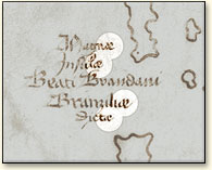
Detail of a map caption, Magnæ Insulæ Beati Brandani Branziliæ Dictæ (the Great Islands of Saint Brendan, called the Branzilians).

|
|
On the Vinland Map, the caption for the Canary Islands and the Azores is written as Magnae Insulae Beati Brandani Branziliae Dictae in which the dipthong is written out -ae. Elsewhere on the Vinland Map it is not and on the Tartar Relation it is never written out.
The Vinland Map uses a virgula to indicate an inter-sentence pause, written as “/”. This is abnormal for the Oberrheinisch Bastarda script and is not used in the Tartar Relation.
Can it be located in time and place?
The script was in use in Germany, Switzerland, France, Flanders and Italy throughout the period ca. 1415 —ca. 1460. Plausibly, its designation is to the Upper Rheinland, and speculatively, to Basle, scene of an important church council ca. 1440.
Is it used consistently or inconsistently (as expected perhaps for a forgery)?
The script appears to be the same for Vinland Map, Tartar Relation and Speculum Historiale. The writing is of uniform size except in the Vinland Map where map captions had to placed in small areas. Capital letters were used much more frequently in the Vinland Map.
Is the Latin usage grammatically correct?
The rendering of Leif Eiriksson as leiphus erissonius (together with other similar examples) suggest a scribe who is not a Scandanavian who knew Latin but a non-Scandanavian who knew Latin but not Icelandic. The rendering of Iceland as Isolanda identifies the scribe as Italian.
Similarly, Vinland appears as Vinilanda, but should have been translated as Terra Labruscarum.
< Previous Next > |